Brief overwiew
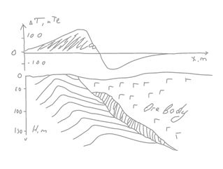
The method is based on measurements of the Earth's magnetic field spatial variations caused by different magnetization of rocks. These variations produce magnetic anomalies – sufficient deviations from background level of Earth’s magnetic field. Their intensity and shape depends on many things like mineral composition of rocks (magnetite or pyrrotite content); shape, size & depth of geological objects; the direction of remanece vector etc.
Measurements of earth’s magnetic field are carried out using magnetometers that are able to detect even its weak deviations over sub-magnetic rocks.
Magnetic surveys are used to detect and map magnetic anomalies and to give their geological interpretation. Sometimes, it is also possible to restore the shape and mineral composition of the anomaly sources.
Wide range of regional-scale mapping and geo-exploration tasks can be solved using magnetometry. It can be useful in defining magnetic anomalies which represent ore (direct detection), or detection structural and compositional complex of intrusive bodies. The magnetometry is also applicable for the fracture zones mapping and hydrothermal rocks detection.
Magnetic survey is cheap enough and high efficient geophysical tool.