Radio-magnetotelluric method
Brief overview
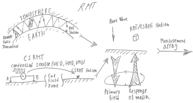
Radiomagnetotelluric (RMT) method belongs to the group of MT methods (MT, AMT, CSAMT) and it is based on measurements of electromagnetic fields of VLF (10-30 kHz), LF (30-300 kHz) and MF (300-3000 kHz) remote radio transmitters. Electromagnetic signal of a remote radio transmitter, recorded on the measurement station, can be discussed as a plane wave. It penetrates into the ground exciting it and inducing EM field. The response function of the media - surface impedance (Z) connects both electric and magnetic components of this EM field and provides the information about electric properties of rocks at the measurement site.
Surface impedance can be transformed to frequency dependencies of the apparent resistivity (ra) and impedance phase (jz) – sounding curves. After their 1D and 2D inversion in corresponding software a geoelectric cross-section can be estimated (resistivities of layers and their boundaries).
The investigation depth of RMT method in the frequency band 10 -1000 kHz is from first meters (high frequencies) to approximately 100 meters (lowest frequencies). Than bigger rock resistivity, than bigger the investigation depth, for example, on crystalline basement it reaches several hundred meters (typically - 100m). Electromagnetic signals of radio transmitters attenuate fast in conductive (10-100 Ohm*m) sedimentary rocks, that is why the depth of RMT soundings decreases to dozens meters (about 30 m). In remote underpopulated regions (like northern Siberia) it is only possible to realize RMT (VLF) profiling at several frequencies instead of standard soundings, because there are not enough high frequency (MF band) radio transmitters,
Since the lowest frequency of VLF radio transmitter is 11.9 kHz (Alpha navigation system), the natural limit of standard RMT technique cannot be lower than this value. A Controlled Source RMT technique allows us to decrease the lower boundary of frequency band to 1 kHz. This feature enables fulfill soundings approximately 3 times deeper – to 150 meters at sedimentary and 400 meters at crystalline rocks comparing with standard RMT. CSRMT technique is typically used in the band 1 -10 kHz, but some CSRMT transmitters can also operate in the rest of RMT band 10-1000 kHz. This is important in remote regions, where there are not enough radio transmitters.
RMT & CSRMT data inversion occurs using well-developed standard MT software. There exists a significant number of well-recommended 1D & 2D inversion tools and also a few 3D ones. So, it is possible to study complicated heterogeneous geological structures.
RMT & CSRMT methods - area of application:
RMT and CSRMT methods are intended for shallow- and middle-depth geophysical studies in range 2-150 m (up to 400 m on resistive structures). They are usually used for hydro-geological, engineering and environmental geophysics etc.
Normally, the duration of measurements is 2-3 minutes per station for RMT and 4-6 minutes per station for CSRMT, so it is possible to carry out about 80 soundings per day (10-50 meters between stations and 20-100 meters between profiles). Thus, the RMT technique is 10 times faster than VES method with 200 m AB distance. In comparison with ERT method, the RMT (CSRMT) one is also faster and it provides more information regarding the resistivity distribution (measurements of several parameters), but it has smaller horizontal resolution because of big enough (20 m) sensor array. The other advantage of RMT/CSRMT technique is using of ungrounded (capacitive) electric antennae which enable measurements at any type of ground including ice, snow, concrete, asphalt etc.
Well-developed 2D inversion algorithms allow studying complicated heterogeneous structures better than it could be done by VES and TDEM methods.